SEVERE WEATHER BULLETIN #11 FOR TYPHOON “#BisingPH” (SURIGAE)
Issued at 5:00 AM, 19 April 2021
TYPHOON “BISING” TURNS NORTH NORTHWESTWARD WHILE MAINTAINING ITS STRENGTH.
• The typhoon is forecast to maintain its current intensity in the next 12 to 24 hours before gradually weakening throughout the remainder of the forecast period.
Location of eye/center
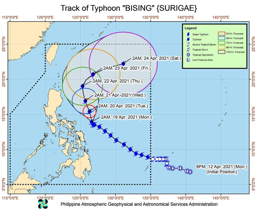
At 4:00 AM today, the center of the eye of Typhoon “BISING” was located based on all available data at 250 km East Northeast of Virac, Catanduanes (14.1°N, 126.5°E).
Strength
Maximum sustained winds of 195 km/h near the center and gustiness of up to 240 km/h.
Movement
Moving North Northwestward at 10 km/h.
Forecast Positions
• 24 Hour (Tomorrow morning): 300 km Northeast of Virac, Catanduanes or 510 km East of Baler, Aurora (15.4°N, 126.3°E)
• 48 Hour (Wednesday morning):430 km East of Tuguegarao City, Cagayan (16.9°N, 125.7°E)
• 72 Hour (Thursday morning): 405 km East of Calayan, Cagayan (19.0°N, 125.3°E)
• 96 Hour (Friday morning):505 km East of Basco, Batanes (20.7°N, 126.8°E)
• 120 Hour (Saturday morning):965 km East Northeast of Basco, Batanes (22.2°N, 131.1°E)
TROPICAL CYCLONE WIND SIGNAL TCWS #2 (61-120 km/h winds prevailing or expected in 24 hours)
• LUZON: Catanduanes, the eastern portion of Camarines Sur (Garchitorena, Presentacion, Caramoan, Sagnay, San Jose, Lagonoy), the eastern portion of Albay (Tiwi, Malinao, Tabaco City, Malilipot, Santo Domingo, Bacacay, Rapu-Rapu, Legazpi City, Manito), and the eastern and central portions of Sorsogon (Castilla, Sorsogon City, Prieto Diaz, Gubat, Barcelona, Casiguran, Juban, Magallanes, Bulan, Bulusan, Irosin, Santa Magdalena, Matnog) Northern
• VISAYAS: Samar, Samar, Eastern Samar, and Biliran TCWS #1 (30-60 km/h winds prevailing or expected in 36 hours) • LUZON: The eastern portion of Isabela (Divilacan, Palanan, Dinapigue), the northern portion of Aurora (Casiguran, Dilasag), the southeastern portion of Quezon (Guinayangan, Calauag, Tagkawayan) including Polillo Islands, Camarines Norte, the rest of Camarines Sur, the rest of Albay, the rest of Sorsogon, and Masbate including Burias and Ticao Islands, Leyte, Southern Leyte, and the northern portion of Cebu (Tabogon, Borbon, San Remigio, Bogo City, Medellin, Daanbantayan) including Bantayan and Camotes Islands
• MINDANAO: Dinagat Islands, Siargao Islands, and Bucas Grande Islands Hazards affecting land areas Heavy Rainfall • Today, moderate to heavy with at times intense rains will be experienced over Bicol Region, Northern Samar, Samar, Eastern Samar, Biliran, and Leyte. • Tomorrow (20 April), moderate to heavy rains will be experienced over Bicol Region and Northern Samar.
• Tropical cyclone winds of at least strong breeze to near gale in strength extend outward up to 440 km from the center of the typhoon. Destructive typhoon-force winds extend outward up to 110 km from the center of the typhoon.
• In the next 24 hours, the northeasterly wind flow enhanced by the typhoon will also bring strong breeze to near gale conditions with higher gusts over most of Northern Luzon, Aurora, and the rest of Quezon that are not under any Tropical Cyclone Wind Signal (TCWS). Such conditions are more likely to occur in the coastal and mountainous areas. Hazards affecting coastal waters In the next 24 hours, under the influence of Typhoon “BISING” and an enhanced northeasterly wind flow, the following sea conditions will be experienced over the coastal waters of the country:.
• Very rough to very high seas will be experienced over the eastern seaboard of Luzon (5.0 to 12.0 m) and rough to very high seas over the northern and eastern seaboards of Eastern Visayas (2.5 to 7.0 m). Sea travel is risky for all types of seacrafts over these waters.
• Rough to very rough seas over the northern and western seaboards of Northern Luzon (2.5 to 5.0 m) and the eastern seaboard of Caraga (2.5 to 4.5 m) and rough seas over the remaining seaboards of localities where wind signals are in effect and the eastern seaboard of Davao Oriental (2.5 to 4.0 m). Sea travel is risky for small seacrafts over these waters. Mariners without the proper experience should immediately seek safe harbor.
• Moderate to rough seas over the western seaboard of Central Luzon (1.2 to 3.0 m). Mariners of small seacrafts are advised not to venture out over these waters. Inexperienced mariners of these vessels should avoid navigating in these conditions. Track and Intensity Outlook
• On the forecast track, Typhoon “BISING” will move generally northward or north northwestward until Wednesday (21 April) evening or Thursday (22 April) early morning. Afterwards, the typhoon will move northeastward throughout Thursday and east northeastward on Friday (23 April) away from the landmass of Luzon.
Source: DOST PAGASA