SEVERE WEATHER BULLETIN #5
FOR: TROPICAL STORM “#SionyPH” (ATSANI)
ISSUED BY DOST PAGASA AT 11:00 AM, 03 November 2020
“SIONY” SLIGHTLY INTENSIFIES AS IT MOVES SLOWLY OVER THE PHILIPPINE SEA EAST OF EXTREME NORTHERN LUZON.
NO TROPICAL CYCLONE WIND SIGNAL
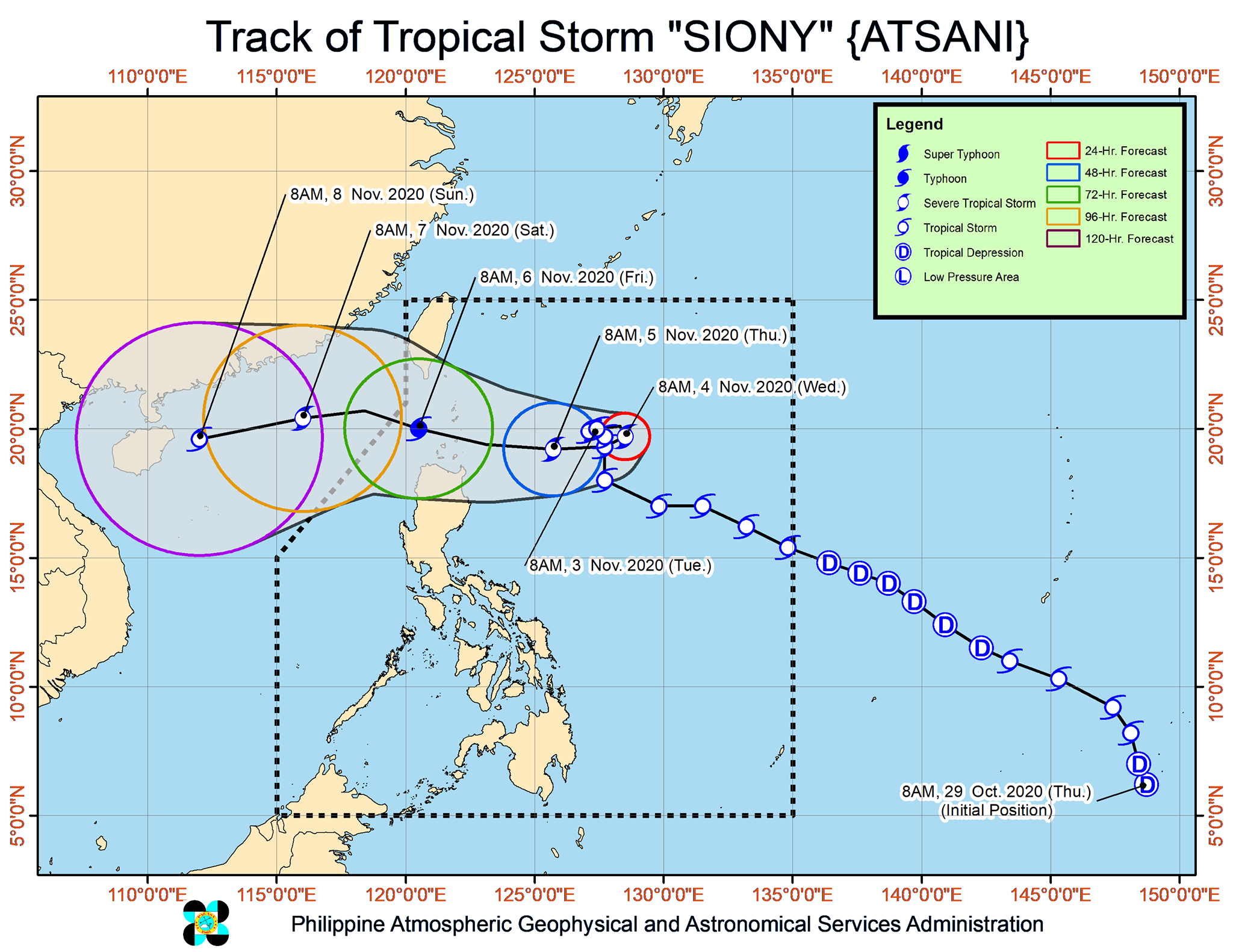
Track and intensity outlook:
• Track: “SIONY” is forecast to move slowly or almost stationary in the next 24 hours. Afterwards, the tropical storm will move generally westward towards Extreme Northern Luzon. A landfall scenario over Batanes-Babuyan Islands area around Friday remains likely. However, due to the projected quasi-stationary state of this tropical storm, there remains a high degree of uncertainty in the forecast track.
• Intensity: “SIONY” is forecast to intensify into severe tropical storm in the next 24 to 36 hours. Intensification into Typhoon is likely on Thursday prior to close approach or landfall over Extreme Northern Luzon.
Location of eye/center: At 10:00 AM today, the center of Tropical Storm “SIONY” was estimated based on all available data at 565 km East of Basco, Batanes(20.2°N, 127.4°E).
Strength: Maximum sustained winds of 85 km/h near the center and gustiness of up to 105 km/h.
Movement: Moving East Northeastward Slowly
Forecast Positions
• 24 Hour (Tomorrow morning): 740 km East of Calayan, Cagayan (19.7°N, 128.5°E)
• 48 Hour (Thursday morning):445 km East of Calayan, Cagayan (19.2°N, 125.7°E)
• 72 Hour (Friday morning): 160 km West Southwest of Basco, Batanes (20.0°N, 120.5°E)
• 96 Hour (Saturday morning):625 km West of Basco, Batanes (OUTSIDE PAR) (20.4°N, 116.0°E)
• 120 Hour (Sunday morning):995 km West of Extreme Northern Luzon (OUTSIDE PAR) (19.6°N, 112.0°E)